With bone-dry conditions, Southern California high fire danger could linger into the new year

By this time of year, Southern California has usually recorded some measurable rainfall. Santa Ana winds, meanwhile, are typically dying down.
But this December, neither is the case.
Precipitation remains well below average, which has kept vegetation bone-dry, and forecasters say powerful offshore winds could pick back up in the next few days.
It’s a recipe that’s likely to keep the threat of wildfires elevated even into January if conditions don’t change.
“The way this winter has started, how dry it is, it could extend our fire season to next year,” said Joe Sirard, a National Weather Service meteorologist in Oxnard. If the rains don’t come and the winds do, he said, “that will keep us in high fire season.”
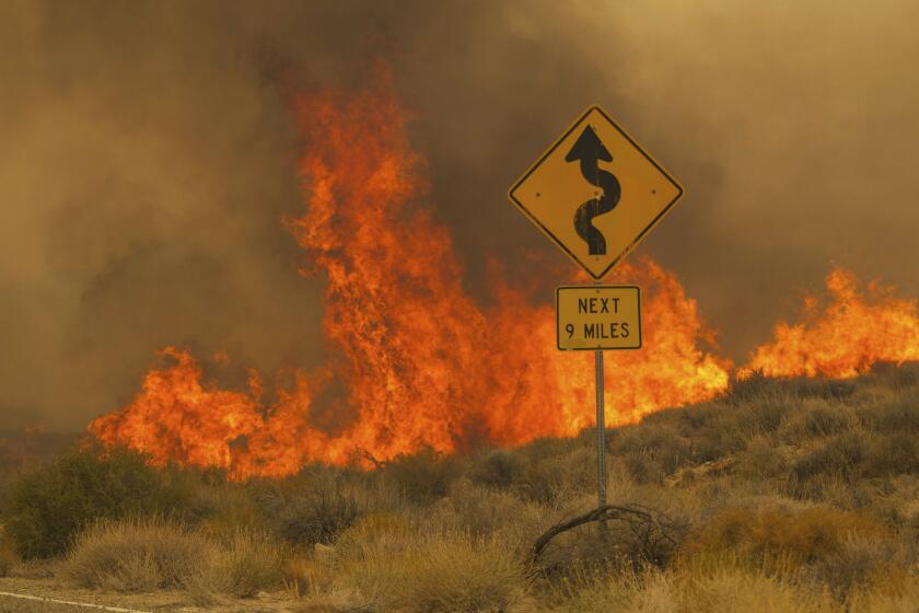
Two recent stretches of dangerous Santa Ana winds played out exactly the way forecasters worried they would, fueling the flames of major fires across coastal Southern California. Just this week, a fire that sparked near Malibu amid the high winds destroyed at least seven homes and scorched more than 4,000 acres. In early November, an even more devastating wildfire charged across southern Ventura County, fanned by hurricane-force winds, exploding to nearly 20,000 acres, destroying more than 180 structures and damaging many more.
In just a few terrifying hours, the Mountain Fire became the most destructive blaze in Southern California in years. The conditions were ripe for disaster, and neighborhoods had few defenses. Here is what happened.
Similar conditions are likely to remain a threat across the Southland, given the latest forecast and climate trends — even as the fire threat in Northern California has mostly faded in the wake of a few drenching rainstorms.
“We’re definitely hoping for the pattern to change to where we actually get significant rain. We just haven’t seen it — not south of Point Conception — yet,” Sirard said.
Downtown Los Angeles has recorded only 0.14 inches of rain from May 6 to Dec. 11 — the third driest such stretch since 1877, Sirard said. Although there’s a slight chance of rain this week, it’s not expected to amount to much if it does materialize.
“Down in the L.A. Basin and the Southern California area, we’re really waiting to see the first significant storm of the season; the fire conditions really don’t abate until you get that first big storm,” said Michael Anderson, the state climatologist. “In the next six days, we really don’t see more than a tenth of an inch falling, which isn’t enough.”
What the forecast is more clear on, however, is a return of the hot, dry offshore winds that can quickly escalate a spark into an erratic fire, Sirard said — as soon as early next week.
Forecasters are anticipating a late start to California’s wildfire season, but they can’t yet say whether it will be severe.
“It does look like we will get some more Santa Ana winds of varying intensity,” Sirard said. “It’s quite possible we could see some more red flag warnings coming up.”
This season has reminded Sirard of 2017’s dry fall and early winter, when the massive Thomas fire exploded across 281,000 acres in Santa Barbara and Ventura counties, destroying over 1,000 structures.
“That was as a result of very, very dry fall and very strong persistent dry winds,” Sirard said.
The lingering fire threat is not entirely surprising, given that coastal Southern California was forecast to have above-normal fire potential this month, according to the National Significant Wildland Fire Potential Outlook. The outlook predicts that the fire threat will drop to a more normal level in January, but there’s a real possibility that it won’t happen.
“Live fuel moisture remains at critically low levels across the region,” the outlook said. “If there are no significant precipitation events in December, there is a chance for January to continue to lean toward above-normal significant fire potential for the [South Coast area].”
There’s also still a tilt toward a La Niña pattern this winter, which favors drier conditions in Southern California and is often associated with drought, although it hasn’t formally developed. Anderson said certain conditions that are often present during La Niña years, like a lingering high pressure system, have already been present, which could be helping keep the Southland so dry.
And while long-range forecasts still show early January in a pattern of below-average rain, Anderson said a storm at the end of December is possible.
But depending on the storms’ strength and path, it could be a bit of a mixed blessing.
“It’s really hard when the fires are burning in December and then having the heavy rain hit — that really increases a danger of the cascading hazard of the landslides [and] debris flows,” Anderson said — like the Montecito mudslides, which crashed through the Thomas fire burn scar and left 23 dead.
That quick swing from fire concerns to water worries has become the increasing challenge of climate change and a warming atmosphere, which provides more energy to power both dry conditions and heavy rains, Anderson said. The warming atmosphere has also extended when California experiences wildfires.
“We’ve seen an increase in fire activity in the months of November and December,” said Jesse Torres, a battalion chief for the California Department of Forestry and Fire Protection. “With climate change… it’s really increased our fire activity and the intensity of our fires.”
Despite a drop in the fire threat in Northern California, he said CalFire’s staffing levels across the state remain high through December. While coastal Southern California is not yet necessarily experiencing a drought, according to the U.S. Drought Monitor, Anderson said that could easily change in the coming weeks if dry weather persists.
“Mother Nature really controls our future and how much fire activity we see in California,” Torres said. “We always want to be ready, we always want to have the resources available.”


